

Leaderboard
-
DaptoFunlandGuy
Members17Points15,646Posts -

StingRay
Members8Points709Posts -
Tin Foil Hat
Members7Points117Posts -
TimmyG
Members5Points142Posts




Popular Content
Showing content with the highest reputation on 13/05/21 in all areas
-
7 points
-
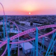
7 pointsIt's a bit more than six weeks old, but here is the latest Nearmap
 7 points
-
6 pointsA couple bonus add-ons for today - as far as I can make out, here's the layout for everyone who only sees a mass twist of timber. (this is my best guess based on the imagery, and is in no way official or confirmed - just thought it'd be a nice add-on for those without nearmap) And finally - the Elevation profile. This line starts at the rear of the station (the 119.5 degree bearing where the transfer track connects) and goes from there. It's obviously not super accurate - firstly because its hand drawn by me and I was lazy and didn't track the curves perfectly, but also because Nearmap captures the height at that spot so it doesn't allow for crossovers and any other track that passes underneath other sections. I found it interesting nonetheless as it captures the height and main drops fairly well.


 6 points
-
5 points
-
2 points
-
Well I mean it's been closed for a while now. No point letting it rot away for longer. It's sitting on prime land that could be utilised so much better than it currently is. Sure for nostalgia purposes, it's sad to see it go. But it's got to. Unless you want a permanent memorial like SW has done with Vikings Revenge.2 points
-
Until it started sinking into the murky Shrek swamp.2 points
-
It also doesn't help that Taipan is built on a berm with a giant retaining wall at the back. It pushes out much further than the boundaries for Gold Rush ever did and it's elevated right up to the train line. It will look very out of place until the groundworks and landscaping is complete. Having to circle the whole park just to get to the northern side near GD is a bit of a pain and really adds to taipan looking out of place too.2 points
-
2 points
-
2 pointsAhh thanks for filling me in... Must be like when Tinder got real popular so Sizzler closed down. i’d swipe left for cheese toast any day...2 points
-
2 pointsI think my favourite part is that they're embracing the fact that the ride is gonna make people scream. Meanwhile all the residents are pouting.2 points
-
It's not simply a new parade, it's an event with returning characters, new shows and yes finishing each day with a large parade. I think you underestimate the nostalgic appeal of some of their old characters.1 point
-
I just hope they get the exhibit sponsored by Compare The Market as Australia Zoo has. 😂1 point
-
tomorrow is going to be a good day for all of us can't wait.1 point
-
https://www.instagram.com/p/COznABdA_ez/?igshid=qbia4uobsswt Movieworld just posted a tease on their Instagram for the announcement. It is set for 8:00am tomorrow. Included is what seems to be the 30th anniversary logo which looks fantastic. Just thought I’d add the logo in case anyone couldn’t access the link. Sorry for the pile up. Just checked and Wet’n’Wild also posted a tease about tomorrows announcement. https://www.instagram.com/p/COznY11rwJo/?igshid=1dlij3tgt11pe. It seems to be the shadow/reflection of a new slide tower on the surface of the water. It’s definitely very intriguing.

 1 point
-
1 pointNah, my money's still on a shaded seating area to replace Arkham. Fingers crossed!1 point
-
1 pointhttps://www.goldcoastbulletin.com.au/business/gold-coast-business/sea-world-gold-coasts-leviathan-roller-coaster-and-trident-ride-in-new-atlantis-precinct-delayed/news-story/f40426cea039e54030681f771bd0a497?fbclid=IwAR3yqOgdQuszvLMbnbtmJVw9UEGf9nTCQgjjN2pQAUCUe3vBexS249NLHxI1 point
-
1 pointLooks like we can see some of the queue in there It’s going to do awesome queuing for this ride with the coaster rushing around everywhere. The noises it’s going to make 👌🏻
 1 point
-
1 pointThe picture I've been waiting for. Certainly is compact and this is not a bad thing at all. Looking forward to the ludicrous amounts of head chopper moments.1 point
-
1 pointIt’s the same for Trident Why would they announce a specific date and then change their mind. I get delays happen, but surely you wouldn’t confirm a date and less you absolutely knew that date was going to happen and everything was in place1 point
-
1 pointOh no, they heard my comment about Steel Taipan going into technical rehearsals on Leviathans opening date1 point
-
1 pointJust noticed the previously announced September 18 date has been replaced with “this summer”.
 1 point
-
In some ways yes. And idk why but I lowkey preferred seeing it without its track pieces put together - especially with that loop - looks odd seeing it complete for me. 🤔 Oh well, won't take long before the theming takes shape and therefore starts to look harmonious with the rest of that area. And it'll be nice going on a thrilling non-concussion coaster at Dreamworld for once 😵1 point
-
Sledgehammers queues are also supposed to be underneath BD so i wonder if they will start the installation of that before the parks reopening especially since the parks ride manager told me that parts of BD have started to arrive in the country i wouldn’t be surprised if we start to see track in the next few weeks1 point
-
There is a hell of a lot of corner cutting on interiors and furnishings, menu offerings, service standards, etc masquerading as ‘modern, chic and cool’ these days and I’m not about it at all.1 point
-
1 pointIt was probably about the same time that Amazon put MySpace out of business1 point
-
Artist impression is on display near Boomerang View of station area Second view showing metal "skeleton" already made. Footer holes have been dug in Maloneys corner. Footers are constructed while future materials for other footers sit and wait. I think we are aiming for a mid-late November soft opening for sure. Things seem to be progressing rather well when it comes to what limited construction they've been able to do so far for BD 3.0


 1 point
-
Accidentally opens it for technical rehearsals the same day that Leviathan is supposed to open1 point
-
Quick photo dump with an extra piece being added to the track currently under the turnaround


 1 point
-
1 point
-
Senior state minister Matt Kean has come forward calling for a Royal Commision style inquiry into the fire, as reported in 9 News tonight: https://fb.watch/5q4G6epcS6/ Also his Private Member's statement in parliament: https://fb.watch/5q4SHdise2/1 point
-
1 pointIf they were smart, they should use this as a chance to free up space in movieworld and move all (or a lot of) the admin related functions village have based at movieworld into the hotel build. Anything that specifically doesn't need to be in the park or require immediate access could be moved and remaining functions condensed into existing buildings or a new facility built.1 point
-
1 pointYou're right. Wet n Wild has a rollercoaster, so why does Movie World need one?1 point
-
You are right but most families visiting are gp and probably wouldn’t know about the ride unless they went to the very back corner. it shows most of the time I go there the queue is usually only 15mins max.0 points
-
Well in case they reveal it early for whatever reason make sure to be on today tomorrow0 points
-
0 points
-
0 points
-
0 pointsits amazing to see that wet'n'wild is finally getting a major new slide after 9 god damn years. vrtp will treated wet'n'wild like the middle child the past few years and finally they are realizing that water parks need rides not off roading.0 points
-
Well that will be sad to see an open day attraction demolished. really does leave a hole for a ride the whole family can enjoy only other ride like that is sky voyager.0 points
-
0 pointshere's a few things i found. in the picture it's hard to see but i'm pretty sure its AOL. they were probably a sponsor for the ride in its early years before aol went under because of google. videos self explanatory movie world in 20090 points











This leaderboard is set to Brisbane/GMT+10:00